
On a recent post concerning bicycling near Round Lake, a comment from Anonymous said...”Since you're in the area, maybe you'd like to stop by and walk across Round Lake.” I would like to think this comment was meant to indicate that Round Lake was dried up. But of course there are other possible implications to this invitation.

I examined and photographed a U.S. Geological Survey map that was based on aerial photographs taken in 1958. (Denham Indiana Quadrangle 7.5 Minute Series Topographic 1962). I then superimposed the terraserver-usa satellite photograph of Round Lake onto the 1958 lake profile. And here is the result:
Map from 1958 Aerial Photos
 above: Black Outline is Present Profile
below: terraserver-usa.com photo Below: 1871 Platt Map
 Below: going, going...
The Division of Fish and Wildlife manages this 140-acre property as a wetland. It seems that the surface area has declined by 60% to 75% since 1958. I assume that a small part of this shrinkage is due to the entropic nature of this lake. Because of the magnitude of the shrinkage, I assume that the Department of Natural Resources has intentionally lowered the lake level. I certainly wonder about their definition of the terms “wetland”and "conservation". It seems to me that this beautiful natural asset has been considerably damaged. I have asked the Indiana Department of Natural Resources for comment on this matter.
1876 Township Map

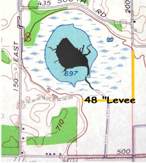
The map above from 1876 shows both Cedar Lake (Bass Lake) and Round Lake. Bass Lake is almost exactly the same size now as it was in 1876. The Lake level has been maintained by a very simple gate at the drainage point. It is my understanding that when the Round Lake was privately owned, a gate maintained the level. I think that it would be a simple matter to restore the lake to the 1958 level. Restoring the 1871 Level would be much more difficult but should be considered. A modest levee on the east half of the south boundary and on the south half of the bast boundary of the Conservation Area should do the trick. The contours of the 1871 lake seem to coincide with the 700-foot elevation on the topographic map. That is only 3 feet above the 1958 level. The levee would be only need to be about 48 inches high.
1871 platt map and 1876 township map from the collection of Starke County Public Library's online collection. http://www.scpl.lib.in.us/historical/
No comments:
Post a Comment